
Characteristics and changes of permafrost along the engineering corridor of National Highway 214 in the eastern Qinghai-Tibet Plateau
2020-03-29 08:06:56YuShengJiChunWuWeiCaoJianHongFangAnHuaXuErXingPeng
Yu Sheng,JiChun Wu,Wei Cao*,JianHong Fang,AnHua Xu,ErXing Peng
1. State Key Laboratory of Frozen Soil Engineering, Northwest Institute of Eco-Environment and Resources, Chinese Academy of Sciences,Lanzhou,Gansu 730000,China
2.Institute of Transportation Sciences of Qinghai Province,Xining,Qinghai 810003,China
ABSTRACT Due to a series of linear projects built along National Highway 214, the second "Permafrost Engineering Corridor" on the Qinghai-Tibet Plateau has formed. In this paper, by overcoming the problems of data decentralization and standard inconsistency, permafrost characteristics and changes along the engineering corridor are systematically summarized based on the survey and monitoring data.The results show that:1)Being controlled by elevation,the permafrost is dis‐tributed in flake discontinuity with mountains as the center along the line. The total length of the road section in per‐mafrost regions is 365 km, of which the total length of the permafrost section of National Highway 214 is 216.7 km,and the total length of the permafrost section of Gong-Yu Expressway is 197.3 km. The mean annual ground tempera‐ture(MAGT)is higher than ?1.5°C,and permafrost with MAGT lower than ?1.5°C is only distributed in the sections at Bayan Har Mountain and E'la Mountain.There are obvious differences in the distribution of ground ice in the differ‐ent sections along the engineering corridor. The sections with high ice content are mainly located in Zuimatan, Duo‐gerong Plain and the top of north and south slope of Bayan Har Mountain. The permafrost thickness is controlled by the ground temperature, and permafrost thickness increases with the decrease of the ground temperature, with the change rate of about 37 m/°C. 2) Local factors (topography, landform, vegetation and lithology) affect the degradation process of permafrost, and then affect the distribution, ground temperature, thickness and ice content of permafrost.Asphalt pavement has greatly changed the heat exchange balance of the original ground, resulting in serious degrada‐tion of the permafrost. Due to the influence of roadbed direction trend, the phenomenon of shady-sunny slope is very significant in most sections along the line. The warming range of permafrost under the roadbed is gradually smaller with the increase of depth, so the thawing settlement of the shallow section with high ice-content permafrost is more significant.
Keywords: characteristics; changes; permafrost; engineering corridor of National Highway 214; Eastern Qinghai-Tibet Plateau
1 Introduction
Permafrost is a kind of special rock and soil which is extremely sensitive to temperature change. With an increase of temperature, permafrost strength decreas‐es greatly. Especially, once the permafrost with high ice-content thaws, its bearing capacity may be com‐pletely lost under the condition of flow plastic. This causes deformation and even damage of various engi‐neering facilities in permafrost regions (Jorgensonet al., 2001; Nelsonet al., 2002). Permafrost is the re‐sult of negative heat accumulation in the surface en‐ergy balance. Climate warming increases the heat in‐come in the stratum, resulting in the global degrada‐tion of permafrost. The degradation of permafrost is mainly manifested by an increase of ground tempera‐ture, the decrease of permafrost table, the thawing of ground ice and the shrinkage of area (Cheng and Wu,2007). Due to reconstruction of the original surface by various engineering activities, the balance of sur‐face energy budget has been greatly changed, result‐ing in fundamental changes in permafrost (Shenget al., 2002).A series of engineering activities in high‐way construction significantly affect the thermal sta‐bility of permafrost under the roadbed. In particular,the laying of black pavement has greatly changed the relationship between surface energy budgets,which makes permafrost thaw from top to bottom.Thawing settlement of permafrost roadbed has be‐come a major problem of highway operation in per‐mafrost regions (Liuet al., 2002; Muet al., 2014;Zhanget al.,2015).
National Highway 214 is an important channel connecting many provinces and regions in western China. It has a total length of 3,256 km, including more than 1,000 km in Qinghai Province. Qinghai is located in an area of high altitude, where National Highway 214 crosses the section of permafrost with a total length of 360 km. Once the traffic volume greatly increases, the damages of permafrost section will occur frequently. In particular, after the Yushu earthquake in 2010, most of the aid and reconstruc‐tion materials were transported through the national road.This increasing traffic volume has seriously re‐stricted the efficiency of highway transportation and greatly threatened traffic safety. The Chinese government immediately started the construction of the Gonghe-Yushu Expressway (Gong-Yu Express‐way) after the Yushu earthquake to fundamentally change the transportation bottleneck of National Highway 214. The Gong-Yu Expressway is basical‐ly arranged in parallel with National Highway 214,and it has been completed and opened to traffic in 2017. At present, a series of linear projects have been completed along National Highway 214, such as highways, transmission lines, and communica‐tion lines.These linear projects form the second "Per‐mafrost Engineering Corridor" on the Qinghai-Tibet Plateau that spans the long-distance permafrost re‐gions. Under the influence of climate warming, the interaction between various projects and underlying foundation will have a significant impact on the per‐mafrost along the engineering corridor (Cheng and Zhao, 2000; Jinet al., 2006; Wu and Zhang, 2008).Once the permafrost degenerates, it will threaten the operation safety of all kinds of projects. There‐fore, it is very important to understand the current status and change trend of permafrost along the en‐gineering corridor for scientific maintenance and safe operation of various projects (Wu and Niu,2013).
The permafrost section of the project corridor is located at the eastern edge of the Qinghai-Tibet Pla‐teau, crossing the two headwaters of the Yellow Riv‐er and the Yangtze River. The regional permafrost is characterized by island and discontinued patch distri‐bution, with high ground temperature and small thickness under the degradation of permafrost due to climate warming (Zhuet al., 1995a; Jinet al., 2010;Luoet al., 2012).As early as the beginning of high‐way construction, it was reported that the permafrost problem of swamp wetland in Chalaping section of National Highway 214 has occurred (Wuet al.,2005). The permafrost along National Highway 214 was firstly investigated with a hydrogeological sur‐vey of the source area of the Yellow River since the 1970s. Affected by construction and operation of National Highway 214, the degradation of perma‐frost in the source area of the Yellow River is obvi‐ous. Thus, this degradation leads to land desertifica‐tion, grassland degradation, groundwater level de‐cline and other ecological environmental problems(Zhanget al., 2004; Lianget al., 2007; Yaoet al.,2015). The status of permafrost was investigated by monitoring the road problems after the road was re‐built (Wenet al., 2009; Liet al., 2010; Yonget al.,2010). Especially, long-term monitoring of perma‐frost change was implemented in order to evaluate the effect of roadbed engineering measures at the ex‐perimental section (Fang, 2011; Fang and Liu,2016). The engineering geological survey of perma‐frost was carried out after the construction of Gong-Yu Expressway in 2010.The distribution and charac‐teristic of permafrost in the road section were ob‐tained (Liuet al., 2019; Donget al., 2020;Taiet al.,2020). Based on the survey data of different periods and sections of the road, different researchers evalu‐ated the engineering geological characteristics of the permafrost roadbed (Zhaoet al., 2011; Liuet al.,2013; Chenet al., 2014; Shenget al., 2015). Perma‐frost along the road is divided into three types ac‐cording the topographic feature, including continu‐ous permafrost(kilometer marks K310?K460,K560?K630),patchy permafrost(K460?K560),and discon‐tinuous permafrost (K630?K670). The permafrost is relatively warm, with MAGT between ?1.5 °C and 0 °C in continuous permafrost regions, approximate‐ly ?0.5 °C in patchy permafrost regions, and higher than ?0.5 °C in discontinuous permafrost regions(Shenget al., 2015). Because the survey data of per‐mafrost are scattered and the standards are not uni‐fied, the distribution and change of permafrost along the engineering corridor are not fully understood. In this paper, the survey data of the previous recon‐struction of National Highway 214 are collected.Through data integration, the data of each stage can be compared. Based on our data comparison, this paper analyzes the basic characteristics and chang‐ing trend of permafrost in the engineering corridor so as to provide reference for future engineering con‐struction and maintenance, regional development and protection.
2 Study area and data collection
2.1 Study area
National Highway 214 basically runs from north‐east to southwest in Qinghai Province. The road section from E'la Mountain to Qingshui River(33°45.8′N?35°34.2′N,97°09.7′E?99°31.5′E) is cov‐ered by permafrost (Figure 1a). The topography in the area is basically dominated by undulating terrain such as mountains and hills with relatively small height and flat terrain such as broad valley,basin and alluvial proluvial plain. The engineering corridor from north to south crosses hills and mountains such as E'la,Jiangluling,Hongtupo,Changshitou,Dayema‐ling, Xiaoyemaling, Chalaping and Bayan Har. The average altitude along the engineering corridor is above 4,000 m, and the highest altitude is 4,831 m,which is located at the pass of Bayan Har Mountain(Figure 1b). Bayan Har Mountain is not only the wa‐tershed between source area of the Yangtze River and source area of the Yellow River, but also an important climate boundary in the east of the plateau (Lin and Wu, 1981). Because this zone is located in the north‐ern boundary of the Indian Monsoon (Wang, 2006),there are obvious differences in climate on both sides of the watershed. Due to the influence of the Indian Monsoon on the south of Bayan Kara Mountain,there is more precipitation, so the region belongs to a temperate zone of semi humid plateau (Lin and Wu, 1981). The surface vegetation is mainly alpine meadow and wetland meadow.The north slope is lo‐cated in the rain shadow area of the Indian Mon‐soon.Except for the mountainous areas with high al‐titude, the vast hills and wide valleys are covered by sparse alpine grasslands or desertification grasslands.The region belongs to the semi-arid plateau sub cold zone (Lin and Wu, 1981). Table 1 presents the main meteorological indicators of weather stations along the engineering corridor.
2.2 Data collection
Numerous drilling and exploration projects in the permafrost of the engineering corridor have been carried out due to renovation and reconstruction of the national highway and expressway. Since the in‐vestigation in different periods and road sections was undertaken by different organizations, perma‐frost data are scattered and data before 1990 was lost.The permafrost data used in this paper comes from six investigations after 1990, with statistics presented in Table 2.
First of all, we rearrange the 1,443 drilling data of permafrost. The recording format is unified and the record information is complemented through da‐ta comparison and on-site inspection. Permafrost borehole data includes key information such as bore‐hole mileage location, geographic location (longi‐tude, latitude and elevation), topography, surface morphology and vegetation coverage. Then, accord‐ing to basic characteristics of topography, landform and permafrost, the engineering corridor is divided into different road sections. Then, differences and similarities of different source data records in each section are compared and analyzed.Through compar‐ative analysis, the reasons for the differences are clear. If the difference is caused by local factors of the borehole location, the original data shall be re‐tained. If the difference is caused by human factors,the original data is corrected. A complete set of sur‐vey data covering all permafrost regions is finally formed through this method. In order to compare temporal and spatial differences of permafrost distri‐bution, the data for 1999 and 2010 separately were integrated. The distribution of permafrost along the line is mainly mapped by the drilling cataloging da‐ta. The data can be used to determine which section is located in a permafrost zone. The ground ice con‐tent of permafrost is generally from borehole core logging. Permafrost is divided into five categories according to ground ice content, including ice-poor,icy, ice-rich and ice-saturated permafrost, and ice layer with soil inclusions. In order to eliminate the description error caused by human factors, ice-poor and icy permafrost are classified as low ice-content permafrost,and other types are classified as high icecontent permafrost.The ground temperature monitor‐ing data can be used to analyze the characteristics of ground temperature, permafrost thickness and degra‐dation state of permafrost.
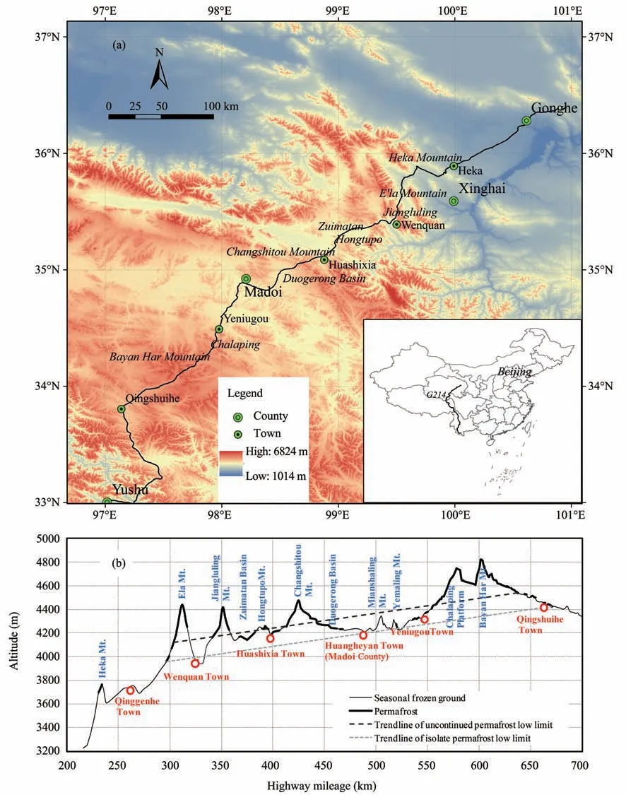
Figure 1 Highway plan location map(a),highway terrain and permafrost distribution map(b)
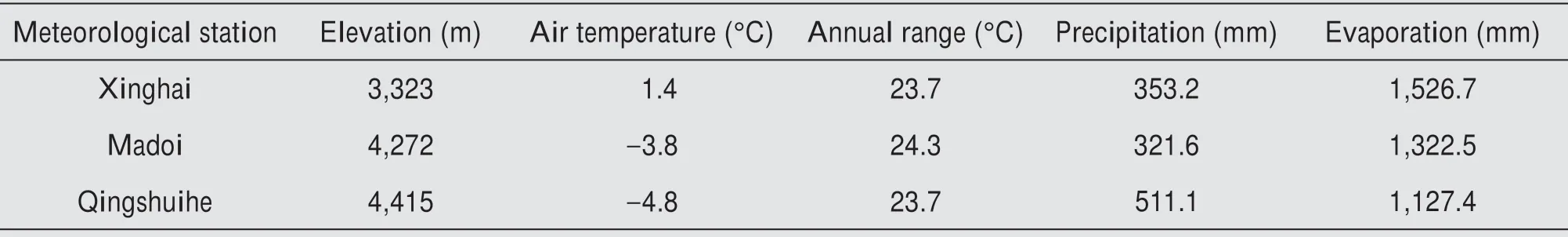
Table 1 Main meteorological indicators of weather stations along the engineering corridor(Average data from 1971 to 2000)
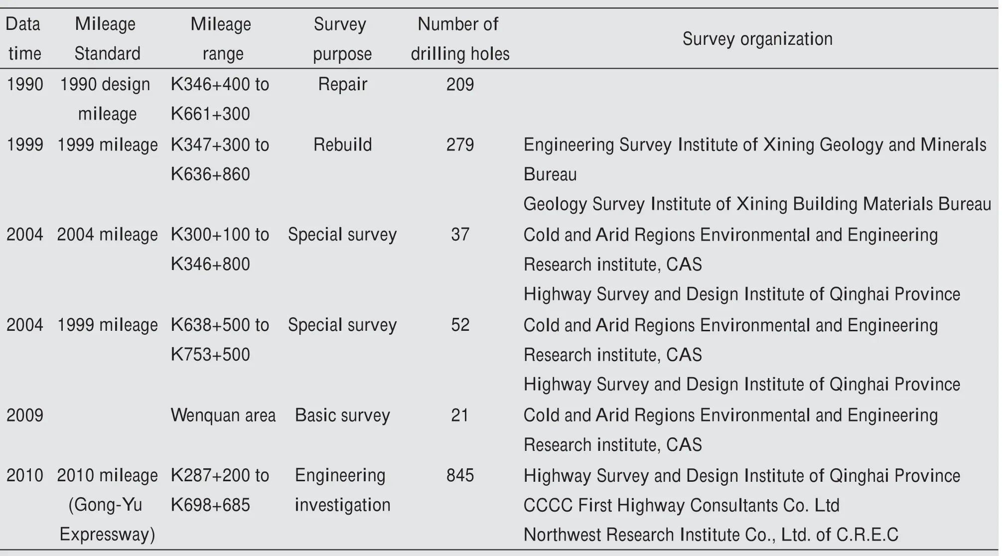
Table 2 Summary of permafrost survey data along the engineering corridor
3 Characteristics of permafrost along the engineering corridor
3.1 Distribution of permafrost
Permafrost along the engineering corridor is locat‐ed in the eastern edge of the high-altitude permafrost regions on the Qinghai-Tibet Plateau. Permafrost dis‐tribution is mainly controlled by altitude. Latitude,longitude and some local factors also have significant impacts on the distribution and characteristics of per‐mafrost along the engineering corridor. The perma‐frost survey along the engineering corridor from north to south shows that permafrost firstly appears in the shady slope of Heka Mountain at an altitude of 3,850 m.The total length of the road section does not exceed 1 km. The permafrsot in this section belongs to a small piece of island-shaped permafrost in the shady slope of the high mountain area. Permafrost,crossed by National Highway 214, is widely distribut‐ed from the north slope of E'la Mountain to Qingshui‐he Town on the south slope of Bayan Har Mountain.Total length of road section crossing permafrost re‐gions reaches to about 365 km(Figure 1b).
Due to low altitude and large topographic fluctua‐tion along National Highway 214,the distribution pat‐tern of permafrost is different from that along the Qin‐ghai-Tibet Highway. Permafrost is mainly distributed in the alpine region and appears discontinuous patchy.Talik is mainly located in the hills,valleys,basins and plains with the low altitude. Table 3 shows the lower limit elevations of permafrost distribution on the north and south sides of several mountains.From data in this table, it can be seen that the lower limit of per‐mafrost along National Highway 214 inclines general‐ly to the northeast.The slope of the lower limit of con‐tinuous permafrost distribution is about 130 m/°N, and the slope of the lower limit of discontinuous perma‐frost is about 260 m/°N. The direction trend of Qing‐hai-Tibet Highway is generally parallel to National Highway 214, and the decline rate of permafrost low‐er-limit along the route is about 100 m/°N with an in‐crease of latitude. In addition, the rate of Xin-Zang Highway is 80 m/°N which is located in the west of Qinghai-Tibet Plateau (Zhouet al., 2000). The distri‐bution of permafrost in the Qinghai-Tibet Plateau is not only controlled by altitude, but also has latitudinal zonality. The distribution of the lower limit of perma‐frost is also affected by dryness zonality.With the de‐crease of dryness, the lower limit of permafrost also tends to decrease on the Qinghai-Tibet Plateau (Cheng,1984). Dryness is controlled by longitude, so it is also called longitude zonality. Permafrost regions of Na‐tional Highway 214 span nearly 2 latitudes and 2.5 longitudes. The lower limit of permafrost along the line declines to the northeast, which is the result of the joint influence of latitude and longitude.The above analysis shows that the change rate of the lower limit of permafrost along National Highway 214 with lati‐tude is larger than that along the Xinjiang-Tibet and Qinghai-Tibet highways. The reason may be that Na‐tional Highway 214 is located in a more eastern posi‐tion,and the influence of longitude zonality is the most prominent. The Xinjiang-Tibet Highway is located in the most western position, with a north-south trend, so there is almost no influence of longitude zonality.
For convenience of discussion, sections along the route are divided according to terrain, and the length and ratio of permafrost distribution in each section are listed in Table 4.
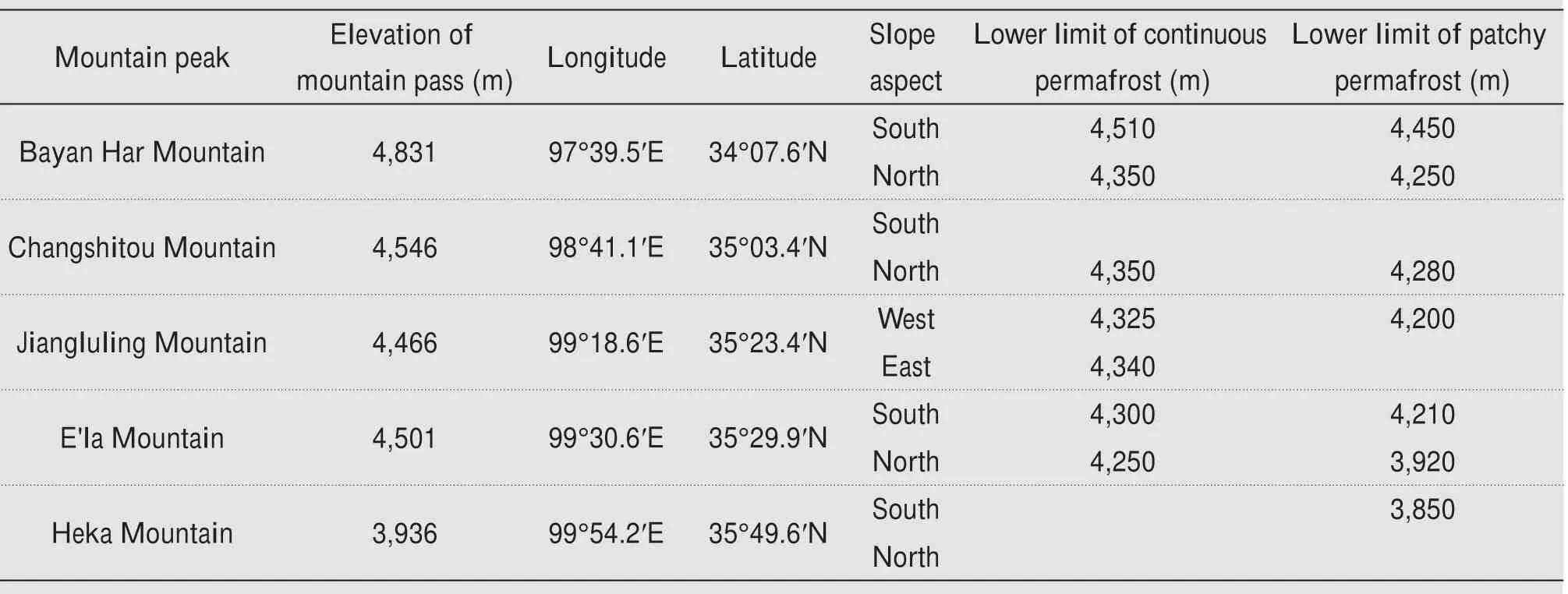
Table 3 Lower limit of altitude of permafrost distribution on both sides of main mountain peaks along the engineering corridor
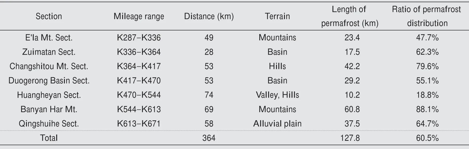
Table 4 Statistics of permafrost distribution along the road sections
3.2 Distribution of ground ice
The content of ground ice is the decisive factor to affect the stability of highway roadbed.The topog‐raphy of National Highway 214 across permafrost regions fluctuates greatly, and the geomorphic types are variable. Under different terrain conditions, the difference of surface water is significant. Under dif‐ferent landform conditions, the lithology changes greatly.All of these determine that there are obvious differences in the characteristics of ground ice in dif‐ferent road sections. In the engineering investigation of permafrost regions in China, permafrost is divid‐ed into five types by volumetric ground-ice content according to Code for Engineering Geological Inves‐tigation of Frozen Ground (GB50324-2014). Gener‐ally, the volumetric ice content higher than 30% are categorized as high ice content permafrost and lower than 30% as low ice content permafrost. Figure 2 is a sectional statistical map of the ground ice type of permafrost along the line.It can be seen from the fig‐ure that sections with high ground-ice content along the line are mainly distributed on Zuimatan, Hongtu‐po, Duogerong and the south and north slopes of Bayan Har Mountain. The landforms of Zuimatan and Duogerong are alluvial proluvial plain and ba‐sin. Because the terrain is flat and the stratum is mainly composed of fine-grained soil, it is condu‐cive to the formation of high ground-ice stratum.Al‐so,the thickness of high ground-ice strata is relative‐ly large, in which perennial frost mounds are dense‐ly distributed in the Duogerong Basin, and there are many thermokarst lakes. Permafrost drilling shows that pure ground-ice layer still distributes below 20 m depth (Wuet al., 2014).The high ground-ice section of Hongtupo is located in the gentle slope of a short length shady slope. The high ground-ice content is mainly distributed in the shallow deluvial and elu‐vial strata.The high ground-ice content on both sides of Bayan Har Mountain is distributed in sections of slope crest and crossing ridge of Chalaping Moun‐tain.With the decrease of height, permafrost is main‐ly distributed in island form, and the high ground-ice strata are mainly distributed in these remaining per‐mafrost islands. The section with high ground-ice content in mountainous area is mainly distributed in the wetland swamp zone with thick accumulation of fine-grained soil. In this area, earth hummocks are intensively distributed on the surface. This kind of high ground-ice layer is mainly distributed in the hilltop of E'la Mountain, the slope toe of northern and southern of Changshitou Mountain and the val‐ley on both sides of Bayan Har Mountain. The high ground-ice layer is mainly concentrated near the per‐mafrost table and the upper layer of permafrost, and its depth is generally within 5 ?6 m. The underlying stratum is generally bedrock or gravel layer with low ice content.
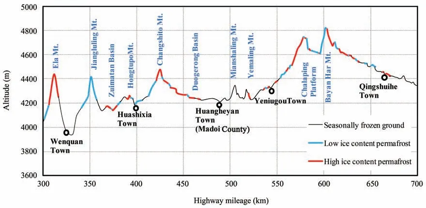
Figure 2 Distribution diagram of ice type in different sections along the engineering corridor
Figure 3 shows the proportion of permafrost and ice types in each section along the engineering corri‐dor. In each road section, the proportion of perma‐frost is different, indicating that the distribution con‐tinuity of permafrost along the line is poor. In the permafrost section, there are also differences in the proportion of permafrost with high and low ice con‐tent. Generally speaking, the proportion of high icecontent sections is relatively low in mountainous ar‐eas, while the proportion is relatively high in plain ar‐eas. The reason is that most highway routes in moun‐tainous areas are located on sunny and gentle slopes to avoid the high ice-content permafrost distributed at the bottom of the valley as much as possible. In these sections, the bedrock is shallower and the coarsegrained soil accumulates more. National Highway 214 and Gong-Yu Expressway are basically parallel,so the distribution of permafrost and type of ground ice along the two lines are basically similar. However,the total length of permafrost section and high ice-con‐tent section of the two lines is slightly different due to the difference of line location and transition section of bridge-tunnel.The total length of the section with high ice content is 120.8 km in the permafrost section with the length of 216.7 km crossing National Highway 214. The length of the section with the permafrost crossing Gong-Yu Expressway is 197.3 km. Excluding the section of tunnel, the total length of the section with high ice content is 92.5 km.
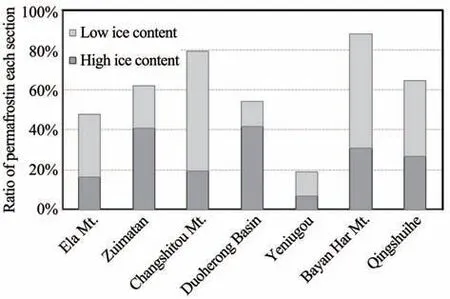
Figure 3 Proportion of permafrost and different ice-containing sections along the engineering corridor
3.3 Ground temperature
Ground temperature is another important factor that affects the stability of permafrost roadbed. The high ice-content permafrost is the material basis of thaw settlement of permafrost roadbed, and the high temperature condition is the driving factor of thaw set‐tlement. According to the engineering experience of Qinghai-Tibet Highway, most of the highway prob‐lems occur in the permafrost sections with high tem‐perature and high ice content (Muet al., 2014). Fig‐ure 4 shows the mean annual ground temperature(MAGT) of the observation boreholes in permafrost regions along the line. This figure shows that MAGT in most road sections along the line is higher than?1.5 °C.According to the statistical data of Qinghai-Tibet Highway, when MAGT is higher than ?1.5 °C,the highway problem-rate increases greatly, which can be used as the basis for classification of high tem‐perature permafrost (Liuet al., 2002; Wu and Niu,2013). Due to the high altitude and dense vegetation,MAGT of three sections of National Highway 214,in‐cluding E'la, Bayan Har and Chalaping mountains, is lower than ?1.5 °C. In addition, it can be seen from the figure that MAGT along National Highway 214 generally follows the altitude zonality,especially in al‐pine areas. But, the influence of local factors is also very significant.The difference of MAGT in the same area can reach 1.5 °C.The MAGT in each section are list in Table 5.
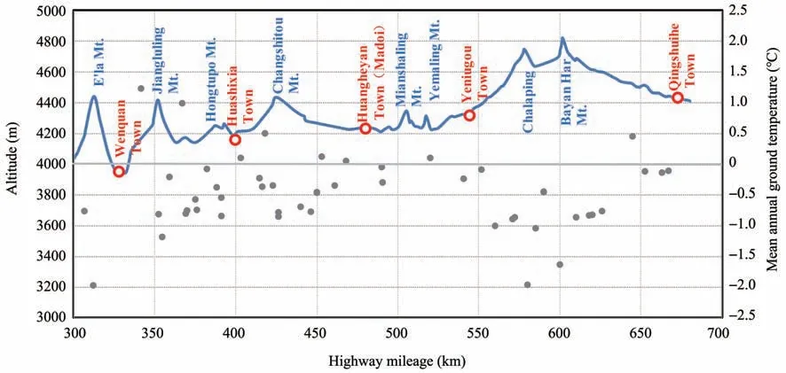
Figure 4 Ground temperature distribution along the engineering corridor
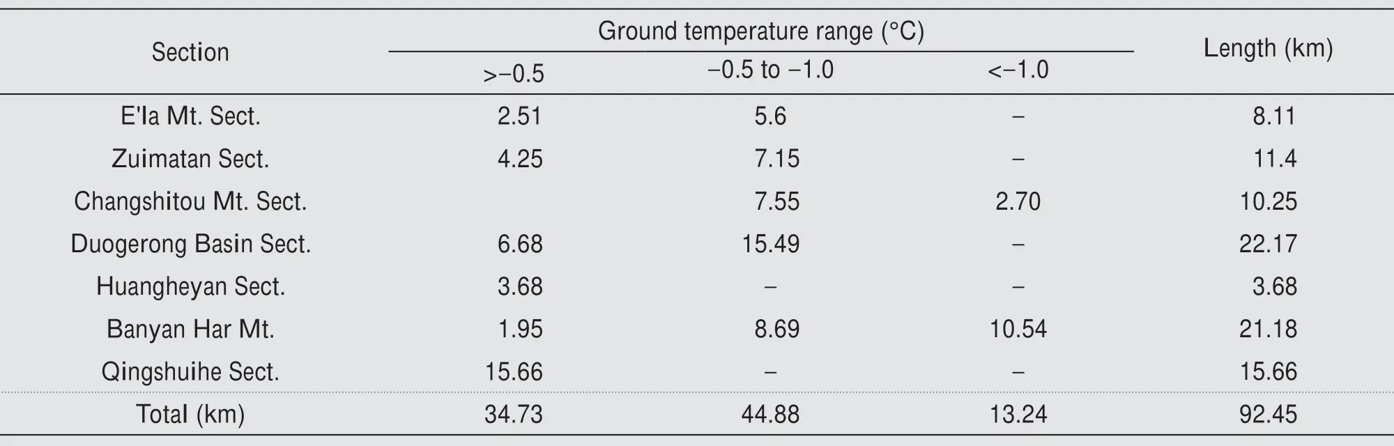
Table 5 Ground temperature distribution statistics of high ice-content section along the engineering corridor
3.4 Permafrost thickness
The permafrost thickness refers to the vertical dis‐tance between permafrost table and permafrost base.In general,the depth of permafrost table is only 2?3 m,so the depth of permafrost base is usually used to rep‐resent the permafrost thickness.The permafrost thick‐ness is controlled by ground temperature and geother‐mal flow. The influence of zonality and local factors on the permafrost thickness is generally indirectly re‐flected by ground temperature. In addition to some tectonic zones, geothermal energy can be considered as constant, so the permafrost thickness can be ap‐proximately regarded as a function of MAGT. In gen‐eral engineering investigation, the drilling depth is within 10 m, some of the temperature measuring holes can reach 20 m, but most of the drilling holes do not penetrate the permafrost layer.In this study,some bore‐holes penetrating the permafrost layer along National Highway 214 were collected, and the relationship be‐tween MAGT and permafrost thickness (depth of per‐mafrost base) was calculated, as presented in Figure 5.Figure 5 shows that the permafrost thickness along Na‐tional Highway 214 increases with the decrease of MAGT,and the change rate is about 37 m/°C.Statisti‐cal results along the Qinghai-Tibet Highway show that the variation rate of permafrost thickness with MAGT is 31 m/°C. The change rate of Qilian Moun‐tain is 27 m/°C (Zhouet al., 2000). Once MAGT de‐creases by 1°C at a depth of 10 m along the Xinjiang-Tibet Highway in the West Kunlun Mountains,perma‐frost thickness will increase by 29 m (Liuet al.,2015).It can be seen from the above comparison that the change rate of permafrost thickness along National Highway 214 with MAGT is significantly larger than that in other regions. This shows that the degree of permafrost degradation along National Highway 214 is stronger than that in other regions.According to the process of permafrost degradation, MAGT increases with permafrost degradation. The geothermal gradient decreases gradually and develops towards the direc‐tion of zero gradient (Jinet al., 2008; Wuet al.,2010). If MAGT is the same, the smaller the geother‐mal gradient is, the greater the permafrost thickness is.This means a greater degree of permafrost degrada‐tion. This is also related to geographical characteris‐tics of permafrost regions where the two highways are located, indicating that the previous study is accurate to confirm the strong degradation of permafrost in this region(Zhuet al.,1995b;Wanget al.,1999).

Figure 5 Relationship between permafrost thickness and MAGT along the engineering corridor
4 Change of permafrost along the engineering corridor
4.1 Spatial distribution of permafrost under the influence of local factors
The distribution of permafrost is not only con‐trolled by zonality, but also influenced by local fac‐tors (Jinet al., 2008; Panget al., 2011). Topography,landform, lithology and vegetation are the main local factors affecting the state of permafrost. In general,these factors controlled by topography form a surface water-heat exchange system which is affected and re‐stricted by each other. The spatial diversity and com‐plexity of permafrost characteristics are caused by dif‐ferent combinations of these factors. The terrain first affects the distribution of permafrost from slope as‐pect. It can be seen from Table 3 that the lower limit of permafrost on the north slope is generally lower than that on the south slope in alpine areas.The high‐way climbs along Shuitara Valley on the north slope of E'la Mountain, and the roadbed of National High‐way 214 is located on the edge of moraine platform on the west bank of the river.The engineering surveys in 1999 and 2004 show that the lower limit of perma‐frost is around 4,250 m.The roadbed of Gong-Yu Ex‐pressway is located on the gentle slope on the east bank, and the marshy wetland is distributed in this ar‐ea. The engineering survey in 2011 shows that the lower limit of permafrost is about 3,920 m.
The alpine region is dominated by bedrock with strong thermal conductivity. The heat flow due to cli‐mate warming is more easily transferred to the perma‐frost layer, leading to its degradation. The plain re‐gion is mainly dominated by loose soil layer with poor thermal conductivity. More importantly, due to the high ice-content in this area, the latent heat con‐sumption of ground ice thawing is large, and the per‐mafrost degradation is relatively slow. Therefore, the degradation rate of permafrost in alpine region is fast‐er than that in plain region, which is due to the influ‐ence of both lithology and ice content. If the differ‐ence is manifested in the distribution of permafrost, it is that the lower limit of permafrost in plain region is lower than that in alpine region. The engineering sur‐vey in 2008 shows that the lower limit of permafrost on the south slope of Jiangluling is 4,325 m,while the lower limit of permafrost of Zuimatan is 4,160 m.Per‐mafrost in front of Zuimatan alluvial-proluvial fan is continuously distributed in flake form. The permafrost in this area not only has high ice content, but also has low MAGT, reaching to ?0.7 °C. Because of the plain terrain, the abundant ground ice delayed the degrada‐tion of permafrost. Similarly, the theoretic lower limit of permafrost on the south slope of Changshitou Moun‐tain is about 4,350 m,but its south slope extends to the gentle plain of the Doggerong Basin. This results in permafrost extending to 4,240 m above sea level at the basin exit before disappearing. The MAGT is about?0.5 °C in the basin. The thick fine-grained soil in the basin contributed to the accumulation of segregated ice and the formation of pingo (Wuet al., 2015). There is still sporadic patchy permafrost under the lower bound‐ary of permafrost in Yematan. This is because of the plain terrain conditions were abundant ground ice de‐lays the degradation of permafrost.
In the alpine region, the highway roadbed is ar‐ranged along the slope toe. In this section, the loose layer is thinly covered and the bedrock is shallowly buried.These sections are mostly covered by low icecontent permafrost or seasonally frozen ground, and only gully sections are possibly covered by high icecontent permafrost.In the valleys adjacent to these ar‐eas, due to the thick accumulation of slope wash and good catchment conditions, the vegetation is mainly wetland meadow.Thus, the valleys are mainly covered by permafrost with high ice content. We have investi‐gated the permafrost in the cross section from river channel to hillside at K591+380, a broad valley on the north slope of Bayan Har Mountain. A concave shape of slope deposits formed from the river bed at the val‐ley bottom to the hillside. With an increase of height and gradient,the fine-grained slope deposits gradually thickened. In the middle and upper section, it reaches the thickest, then gradually thins, and gradually tran‐sits to the eluvial hillslope. In this process, the ground temperature of permafrost first decreased and then in‐creased. The ground temperature of permafrost was the lowest in the place with the thickest accumulation of slope deposits. The talik is even formed at the slope toe where the residual deposits accumulate.
Qingshuihe section, located on the southern pied‐mont of Bayan Har Mountain, span the patchy perma‐frost zone with about 40 km. It's the longest patchy permafrost zone along the engineering corridor. In 2004, a special investigation of permafrost found that permafrost was mainly distributed in the river terrace with high terrain in the wide valley of Qingshui River.Most of the vast floodplain is covered by seasonally frozen ground. Figure 6 shows the distribution of per‐mafrost in Qingshuihe section along the National Highway 214. The same pattern of permafrost distri‐bution was also confirmed in the engineering geologi‐cal investigation of Gong-Yu Expressway in 2010.
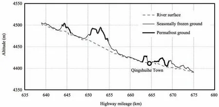
Figure 6 Permafrost distribute in Qingshuihe section along the engineering corridor
4.2 Permafrost degradation under climate warming and human activities
Overall, permafrost along the National Highway 214 has been significantly degraded. The degradation of permafrost is manifested in the increase of ground temperature, the decrease of permafrost table and the thawing of ground ice. Wanget al. (1999) reported the detachment of frozen ground and residual thawed layer found in the excavation of drilling and civil wa‐ter wells of the patchy permafrost zone near Huashix‐ia, Madoi County and the Qingshui River. Moreover,deep-buried residual permafrost was also found in the drilling excavation in Zuimatan, Huashixia, Maduo,north bank of Xingxinghai and Qingshuihe.The uplift of the lower limit of permafrost is the direct evidence of permafrost degradation in past studies. Research shows that since 1990, the lower limit of permafrost of E'la Mountain and Jiangluling has increased by 50 ?100 m, Changshitou Mountain by 130 m, north and south slope of Bayan Har Mountain by 50 m and 70 m (Zhuet al., 1995a; Jinet al., 2010; Luoet al.,2012). Figure 7 shows the ground temperature curve of natural hole in the monitoring section K670+300 of Qingshui River of National Highway 214. This figure shows that the permafrost table has dropped to about 8.5m (curve on October 16,2016).The freezing depth is only about 6.0 m on April 4, 2015, when the freez‐ing reached to the most depth. In the depth range of 6.0?8.5 m, ground temperature maintained 0 °C dur‐ing the whole winter, just like the zero curtain phe‐nomenon,which is in the mixed state of ice-water and not completely frozen. Figure 8 shows the ground temperature curve of natural hole in monitoring sec‐tion K416+300 of Huashixia of the National Highway 214. When the ground temperature of permafrost is close to zero gradient, the thawing rate of permafrost base rises by 4 m in five years, which is much faster than the rate of moving down of permafrost table.
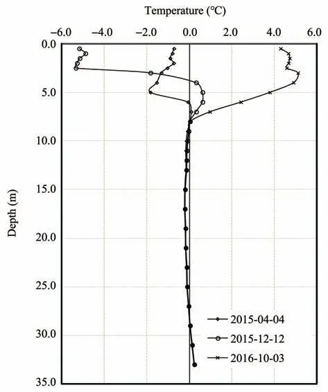
Figure 7 Ground temperature curve of natural hole K670+300 of National Highway 214
Highway engineering construction has a signifi‐cant impact on the thermal state of the underlying per‐mafrost. In particular, strong heat absorption of as‐phalt pavement makes the permafrost degradation more serious (Wuet al., 2001). Figure 9 shows the comparison of ground temperature at depths of 0.5 m and 5.0 m before and after the paving of asphalt at K430+070 monitoring section of Gong-Yu Express‐way. The asphalt pavement was completed in June 2014, and the ground temperature difference at the depth of 0.5 m of the natural hole is about 8°C.As the engineering activities greatly change the surface con‐ditions, the annual range of 0.5 m depth in the road‐bed is enlarged to about 28 °C. Moreover,after asphalt pavement, the ground temperature in winter is signifi‐cantly higher than before paving. Due to the high ice content and the silty clay at the depth of 5.0 m, the ground temperature under the roadbed is significantly higher than that of the natural ground.Ground temper‐ature under the roadbed is close to the thawing tem‐perature of permafrost(about ?0.2°C),and remains un‐changed within the year. This indicates that the ground ice may have begun to thaw.
Figure 8 Ground temperature curve of natural hole K416+300 in Huashixia,National Highway 214
Asphalt pavement of National highway 214 began in 2003, and the main alpine region was paved with light-colored concrete. The roadbed height of K369+210 section at Zuimatan is 2.1 m, the natural upper limit of permafrost is 1.8 m, and MAGT is ?0.95 °C.Figure 10a shows the change of ground temperature in the center of roadbed during about 10 years of as‐phalt pavement. It can be seen from this figure that,after deducting roadbed height, the artificial upper limit of permafrost under the roadbed is about 4.0 m lower than the natural upper limit of permafrost in 10 years. Figure 10b shows the variation trend of ground temperature at depths of 8 m and 15 m. In the past 10 years, the rising rate of ground temperature at 8 m depth reaches to 0.05 °C/a, while that at 15 m depth is 0.016 °C/a, which is equivalent to the rise rate of ground temperature in natural state.This shows that the asphalt road has a strong heating effect on the underly‐ing permafrost, but its influence depth has a certain limit. This is because the temperature rise of the per‐mafrost layer under the roadbed causes a heat transfer in a horizontal direction, and the permafrost layer with lower temperature under the natural ground on both sides has a cooling effect on the permafrost under the roadbed. With an increase in depth, the vertical heat transfer decreases gradually.At a certain depth,the hor‐izontal heat transfer can compensate the heat trans‐ferred from the vertical direction.The influence depth of heating in vertical direction is related to pavement width.The wider the pavement is,the greater the heat‐ing depth. Therefore, in order to ensure the horizontal heat exchange between the natural ground and perma‐frost under the roadbed, it is necessary to maintain a certain distance between the linear projects in the proj‐ect corridor (Maet al., 2017). Figure 10c shows the comparison of ground temperature at three different po‐sitions on the section.It can be seen that the permafrost table in the center of roadbed decreases the most, fol‐lowed by the left shoulder on the sunny slope, and the right shoulder on the shady slope.Whether it is Nation‐al Highway 214 or Gong-Yu Expressway, the road trend determines that most roadbeds have problems of asymmetric thawing or freezing of the shady-sunny slope. The asymmetric freeze-thaw characteristic of the shady-sunny slope is one of the main reasons for the longitudinal cracks and uneven settlement of the roadbed(Chouet al.,2008;Wuet al.,2011).
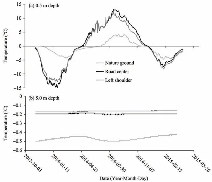
Figure 9 The variation of surface temperature in K430+070 section of Gong-Yu Expressway of 0.5m(a)and 5.0m(b)
5 Conclusions
In this paper,permafrost characteristics and chang‐es along the engineering corridor of the National Highway 214 are systematically summarized based on permafrost survey data and monitoring data. The main conclusions are as follows:
(1) The permafrost along the engineering corridor of the National Highway 214 is located in the eastern edge of a large continuous permafrost belt on the Qin‐ghai-Tibet Plateau. Permafrost is distributed in flake discontinuity with mountains as the center along the line.The total length of the road section in permafrost regions is 365 km,of which the total length of the per‐mafrost section of National Highway 214 is 216.7 km,and the total length of the permafrost section of Gong-Yu expressway is 197.3 km. There are obvious differ‐ences in the distribution of ground ice in the engineer‐ing corridor. The sections with high ice content are mainly located in Zuimatan, Duogerong Plain and the top of north and south slope of Bayan Har Mountain.Most of the patchy permafrost located in plain, valley and gentle slope sections generally have high ice con‐tent. The MAGT in the engineering corridor is higher than ?1.5 °C, and permafrost with MAGT lower than?1.5 °C is only distributed in the sections at Bayan Har and E'la mountains. The total length of perma‐frost section with high temperature and high ice con‐tent is more than 90 km. The permafrost thickness in the engineering corridor is controlled by the ground temperature, and permafrost thickness increases with the decrease of ground temperature, with the change rate of about 37 m/°C.
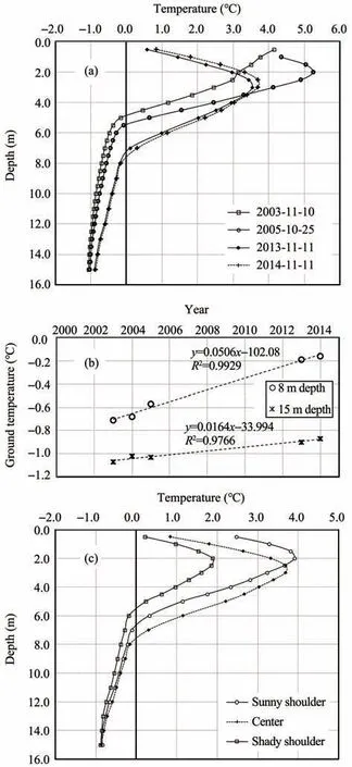
Figure 10 Variation of ground temperature on section K369+210 of National Highway 214.(a)Ground temperature curve of the central hole of the roadbed in different periods;(b)Heating rate at depths of 8 m and 15 m in the central hole;(c)Comparison of ground temperature at different locations in the same period
(2) Under the background of degradation, the per‐mafrost edge zone is significantly affected by local factors. Local factors (topography, landform, vegeta‐tion and lithology) affect the degradation process of permafrost, and then affect the distribution, ground temperature, thickness and ice content of permafrost.Highway construction along the line has a significant impact on permafrost under the roadbed. Asphalt pavement has greatly changed the heat exchange bal‐ance of the original ground,resulting in serious degra‐dation of the permafrost. Due to the influence of the roadbed trend, the phenomenon of shady-sunny slope is very significant in most sections along the line.The warming range of permafrost under the roadbed is gradually smaller with an increase of depth, so the thawing settlement of the shallow section with high ice-content permafrost is more significant.
Acknowledgments:
This research was supported by the National Natural Science Foundation of China(Grant No.41971093).
 Sciences in Cold and Arid Regions2020年6期
- Sciences in Cold and Arid Regions的其它文章
- Guidelines to Authors
- Glacier changes in the Qaidam Basin from 1977 to 2018
- Thickness estimation of the Longbasaba Glacier:methods and application
- Zhangmu and Gyirong ports under the threat of glacial lake outburst flood
- Spatial distribution of supraglacial debris thickness on glaciers of the China-Pakistan Economic Corridor and surroundings
- Manifestations and mechanisms of mountain glacier-related hazards